The Earth’s crust is constantly changing, even when these changes are too slow to notice in everyday life. Mountains rise, rocks bend under pressure, faults develop, and layers of the Earth’s crust shift over time. These changes create the geological structures that shape landscapes and influence natural processes. The scientific field that studies these structures is called structural geology. It helps scientists understand how rocks deform, how geological forces act inside the Earth, and how the crust has changed throughout geological history.
Structural geology is important in many areas, including earthquake research, mountain formation, mineral exploration, groundwater studies, and engineering projects. By examining the arrangement, orientation, and deformation of rocks, geologists can reconstruct past geological events and identify potential risks associated with natural hazards. Understanding structural geology therefore provides valuable knowledge about the Earth’s history, resources, and physical stability.
What Is Structural Geology?
Structural geology is a branch of geology that studies the shape, arrangement, orientation, and deformation of rocks and geological features within the Earth’s crust. It focuses on how rocks respond to forces such as compression, tension, and shear, which can cause them to bend, break, fold, or move.
These forces act over different periods and at different depths beneath the Earth’s surface. Some geological structures form deep underground under high temperatures and pressures, while others develop closer to the surface under relatively low-pressure conditions.
For example, when two sections of the Earth’s crust move toward each other, rock layers may become compressed and folded. When rocks break and move along a fracture, a fault may form. Structural geologists study these features to understand the forces responsible for their formation.
Structural geology also examines the relationships between different rock layers and structures. By observing their orientations and patterns, scientists can determine how rocks have been affected by geological events over millions of years.
Why Is Structural Geology Important?
Structural geology provides essential information about the processes that shape the Earth. Its importance extends beyond understanding rocks because geological structures influence natural hazards, underground resources, and the safety of construction projects.
The following sections explain its major applications.
Major Geological Structures Studied in Structural Geology
Structural geologists investigate several types of geological structures. Each structure provides clues about the forces that have acted on the Earth’s crust.
1. Folds
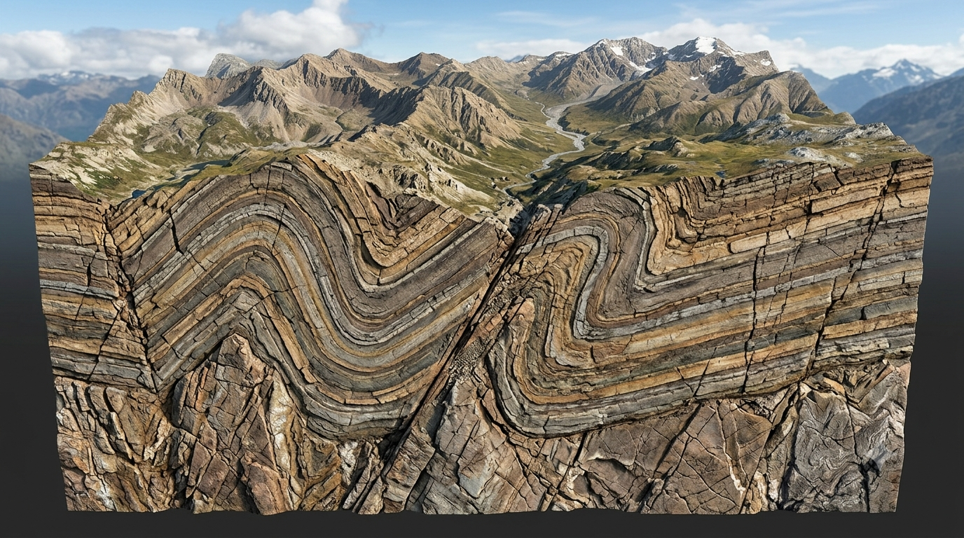
Folds are bends or curves that develop in rock layers, commonly when rocks experience compression. Instead of breaking immediately, some rocks deform gradually and form curved structures.
Folds are especially common in regions where tectonic plates collide and mountain ranges develop.
The two basic types of folds are:
Anticlines: These are generally upward-arching folds in which the oldest rocks occur near the center when the sequence has not been overturned.
Synclines: These are generally downward-curving folds in which the youngest rocks occur near the center when the sequence has not been overturned.
Folds can vary greatly in size. Some are only a few centimeters across, while others extend for many kilometers. Their shapes and orientations help geologists understand the direction and intensity of deformation.
Folds are also important in petroleum exploration because certain folded rock formations can create traps where oil and natural gas accumulate beneath impermeable layers.
2. Faults
A fault is a fracture or zone of fractures in rock along which measurable displacement has occurred. Faults develop when stresses exceed the strength of rocks or when existing weaknesses are reactivated.
Faults are closely associated with tectonic activity and can produce earthquakes when stored stress is released through sudden movement.
The main types of faults include:
Normal faults: These commonly develop when the Earth’s crust is stretched. The hanging wall moves downward relative to the footwall.
Reverse faults: These form under compression, with the hanging wall moving upward relative to the footwall.
Thrust faults: These are low-angle reverse faults that can transport large rock masses over other rocks.
Strike-slip faults: These involve predominantly horizontal movement along the fault.
Studying faults helps geologists understand crustal movement, identify earthquake-prone areas, and interpret the geological history of a region.
3. Joints
Joints are fractures in rocks along which there has been no significant visible displacement parallel to the fracture surface. They can develop because of cooling, pressure changes, tectonic stresses, or the release of stress as rocks are exposed at the surface.
Joints are important because they influence the strength and permeability of rock masses. Water can move through connected joints, affecting groundwater circulation and the stability of slopes.
In construction, joints may also influence the behavior of foundations, tunnels, dams, and road cuttings. Engineers must understand their orientation, spacing, and condition before building on or within fractured rock.
4. Foliation and Lineation
Foliation is a planar arrangement of minerals or structural features in rocks. It commonly develops when rocks experience directed pressure and minerals become aligned or reorganized.
Lineation refers to a linear arrangement of minerals or other geological features within a rock.
These structures are especially common in metamorphic rocks, which form when existing rocks are altered by heat, pressure, or chemically active fluids without completely melting.
Foliation and lineation help geologists determine how rocks were deformed and identify the direction of geological movements. They are particularly useful when studying mountain-building processes and rocks that have undergone intense deformation deep within the Earth’s crust.
The Forces That Deform Rocks
Rocks experience different types of stress as a result of tectonic movements, gravitational forces, and other geological processes. Structural geology examines how these stresses change the shape and position of rock masses.
Compression
Compression occurs when forces push rocks toward one another. It can shorten and thicken the Earth’s crust, causing rock layers to fold or break along reverse and thrust faults.
Compression is an important process in the formation of mountain ranges, particularly where tectonic plates converge.
Tension
Tension occurs when forces pull rocks apart. It stretches the crust and may cause rocks to fracture or move along normal faults.
Tensional forces are common in rift valleys and regions where the Earth’s crust is being extended.
Shear
Shear stress acts parallel to a surface, causing different parts of a rock mass to move past one another. It can produce faults, mineral alignment, and other deformation structures.
Shear deformation is particularly important near transform plate boundaries and within large zones of crustal movement.
Ductile and Brittle Deformation
Rocks do not always respond to stress in the same way. Their behavior depends on factors such as temperature, pressure, mineral composition, the presence of fluids, and the rate at which stress is applied.
Brittle deformation occurs when rocks fracture or break. It is common under relatively cool, low-pressure conditions near the Earth’s surface.
Ductile deformation occurs when rocks change shape without breaking apart on the scale being observed. It is more common at greater depths, where higher temperatures and pressures can allow rocks to deform gradually.
These behaviors are not determined by depth alone. Rock type, deformation rate, and local geological conditions also influence how rocks respond to stress.
How Structural Geologists Study Rock Structures
Structural geologists use field observations, measurements, laboratory studies, and modern technology to understand geological deformation.
Field Mapping
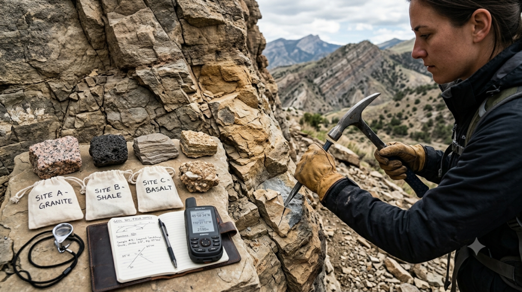
Field mapping is one of the most important methods in structural geology. Geologists examine exposed rocks in mountains, cliffs, river valleys, road cuttings, quarries, and other locations.
They record the locations of rock layers, folds, faults, joints, and other features. These observations are used to prepare geological maps that show how different structures are distributed across an area.
Field mapping also helps scientists identify relationships between geological features and reconstruct the sequence of events that formed them.
Measuring Strike and Dip
Strike and dip are fundamental measurements used to describe the orientation of planar geological features, such as bedding planes, faults, and foliation.
Strike is the compass direction of a horizontal line on an inclined geological plane.
Dip is the angle at which that plane slopes downward from the horizontal, measured perpendicular to the strike direction.
For example, a rock layer might have a strike of east–west and a dip of 30 degrees toward the south. This means that the layer trends approximately east–west and slopes downward toward the south at 30 degrees.
These measurements help geologists interpret folded rock layers, determine fault orientations, and construct cross-sections that reveal the structure of the Earth’s crust below the surface.
Geological Cross-Sections
A geological cross-section is a vertical representation of the rocks and geological structures beneath a particular line across the landscape.
Cross-sections show the arrangement of rock layers, faults, folds, and other features below the ground. They are commonly created using field observations, geological maps, borehole information, and geophysical data.
Cross-sections help geologists visualize underground structures that cannot be observed directly at the surface.
Remote Sensing and Geophysical Surveys
Modern structural geology increasingly uses satellite imagery, aerial photographs, drone surveys, and digital elevation models to identify geological patterns over large areas.
Geophysical methods provide additional information about underground structures. For example, seismic surveys measure how seismic waves travel through the subsurface, while gravity and magnetic surveys identify variations associated with different rock types and geological features.
These techniques are particularly valuable in regions where rocks are covered by soil, vegetation, water, or human-made structures.
The Role of Structural Geology in Earthquake Studies
Structural geology is essential for understanding the geological conditions associated with earthquakes.
Earthquakes often occur when stress accumulated along a fault is released through sudden movement. By studying the orientation, geometry, and history of faults, geologists can identify structures that may be capable of generating earthquakes.
Fault mapping helps researchers understand how different sections of the crust are connected and how deformation is distributed across a region.
Structural information also supports seismic hazard assessments, which estimate the likelihood and potential effects of earthquake shaking over a specified period.
However, identifying a fault does not mean that scientists can predict exactly when an earthquake will occur. Earthquake timing remains difficult to predict, and structural geology is one part of a broader approach that includes seismology, geodesy, and historical earthquake records.
Importance of Structural Geology in Mountain Formation
Mountain ranges often develop through the interaction of tectonic plates and the deformation of the Earth’s crust.
When plates converge, compressional forces may fold rock layers, create reverse faults, and push large rock masses over one another. These processes can thicken the crust and contribute to mountain building.
Structural geologists examine these features to understand how mountains formed and how they have changed over geological time.
For example, the Himalayas developed through the collision of the Indian and Eurasian plates. The region contains extensive folds, thrust faults, and other structures associated with crustal shortening and uplift.
By studying these structures, scientists can reconstruct the sequence of tectonic events that contributed to the development of the mountain range.
Structural geology also helps explain why mountain landscapes contain different rock types, steep slopes, valleys, and zones of fractured rock.
Applications in Mineral and Energy Exploration
Structural geology plays an important role in identifying and understanding underground natural resources.
Mineral Exploration
Many mineral deposits form or become concentrated along faults, fractures, folds, and other geological structures. These features can provide pathways for mineral-rich fluids or create suitable environments for mineral deposition.
Geologists use structural information to identify promising exploration areas and understand the shape and distribution of mineralized zones.
Structural analysis is not sufficient by itself to confirm the presence of an economically valuable deposit. It is usually combined with geochemical testing, geophysical surveys, drilling, and detailed geological mapping.
Petroleum Exploration
Oil and natural gas can accumulate in porous reservoir rocks when suitable geological conditions are present. Structural traps, including certain anticlines and fault-bounded formations, may prevent hydrocarbons from migrating farther upward or sideways.
Structural geologists help identify these traps and assess their geometry.
Faults can either help or hinder hydrocarbon accumulation, depending on the properties of the fault zone and surrounding rocks.
Geothermal Energy
Geothermal energy uses heat from within the Earth. Faults and fractures can influence the movement of hot water and steam through underground rock formations.
Structural studies help identify potential fluid pathways and improve understanding of the geological conditions needed for geothermal systems.
Why Structural Geology Matters in Engineering and Construction
Structural geology is important for evaluating the ground conditions on which buildings, roads, bridges, tunnels, dams, and other infrastructure are constructed.
A site may appear stable at the surface while containing faults, weak rock layers, fractures, or steeply inclined bedding planes beneath the ground.
These features can influence the strength and stability of foundations, excavation walls, and natural slopes.
Building Foundations
Before major construction begins, engineers need information about the type, strength, orientation, and condition of the underlying rock.
Rock layers that dip toward an excavation, closely spaced joints, or weak fault zones may affect foundation design. Geological investigations help engineers identify these conditions before they become serious construction problems.
Tunnels and Underground Structures
Tunnels frequently pass through rock masses containing joints, faults, and folded layers. These structures can affect excavation difficulty, groundwater inflow, and the risk of rock falls or collapse.
Structural geological mapping helps engineers select appropriate excavation methods, support systems, and drainage measures.
Dams and Reservoirs
Dams require stable foundations and careful assessment of groundwater movement. Fractures and faults can provide pathways for seepage, while certain discontinuities may reduce the strength of the foundation rock.
Understanding the orientation and condition of these structures helps engineers evaluate potential risks and plan suitable mitigation measures.
Landslides and Slope Stability
Structural geology also supports landslide assessment. Slopes may become unstable when rock layers, joints, or faults create surfaces along which material can slide.
The risk depends on several factors, including the orientation of geological discontinuities, rock strength, water pressure, weathering, slope angle, and external disturbances.
Geological investigations can identify unfavorable structural conditions and support safer planning for roads, buildings, and other infrastructure in mountainous regions.
Structural Geology and Groundwater
Groundwater moves through pores, fractures, and other openings in geological materials. In solid rock, faults and joints may provide important pathways for water movement.
However, not all geological structures increase groundwater flow. Some fault zones contain fine-grained materials or minerals that block water movement and act as barriers.
Structural geology helps hydrogeologists understand how these features influence groundwater storage, recharge, and movement.
This knowledge is useful when selecting locations for wells, planning groundwater extraction, and evaluating the movement of potential contaminants through fractured rock.
It also supports the assessment of groundwater conditions around tunnels, mines, dams, and other major construction projects.
The Relationship Between Structural Geology and Plate Tectonics
Plate tectonics explains how large sections of the Earth’s lithosphere move and interact. Structural geology examines many of the rock structures produced by these movements.
At convergent boundaries, compression can produce folds and reverse faults. At divergent boundaries, stretching can create normal faults and rift systems. At transform boundaries, horizontal movement commonly produces strike-slip faults.
These structures preserve evidence of past and present tectonic activity.
By combining structural observations with information about rock ages, geochemistry, and geophysics, scientists can reconstruct the geological development of continents, ocean basins, and mountain belts.
Structural geology therefore provides a valuable connection between the visible features of rocks and the large-scale processes operating within the Earth.
Challenges in Structural Geology
Although structural geology provides powerful tools for understanding the Earth, studying geological structures can be challenging.
Many important structures lie deep underground and cannot be observed directly. Geologists must interpret them using indirect evidence from drilling, seismic surveys, surface mapping, and other techniques.
Rocks may also have experienced several periods of deformation. A fold may be cut by a younger fault, or an older fault may be reactivated by later tectonic forces. Separating these events requires careful observation and interpretation.
Another challenge is that geological structures can change significantly over short distances. A model that works well in one part of a region may not accurately represent another area.
For these reasons, structural interpretations often involve uncertainty. Scientists improve their understanding by comparing independent sources of evidence and updating geological models when new information becomes available.
Conclusion
Structural geology is a fundamental branch of Earth science that explains how rocks are arranged, deformed, fractured, and displaced by geological forces. Through the study of folds, faults, joints, foliation, and other structures, geologists can reconstruct the history of the Earth’s crust and understand the processes responsible for mountain formation, tectonic movement, and many natural hazards.
Its importance extends into earthquake research, mineral and energy exploration, groundwater management, and engineering projects. Structural geological investigations help identify weaknesses in rock masses, evaluate potential hazards, and support safer decisions about land use and infrastructure development.
Although many geological structures remain hidden beneath the surface, advances in mapping, remote sensing, and geophysical technology continue to improve our understanding of them. Structural geology therefore remains essential for explaining how the Earth changes and for using its natural resources and landscapes responsibly.
FAQs
1. What is structural geology?
Structural geology is a branch of geology that studies the arrangement, orientation, shape, and deformation of rocks in the Earth’s crust. It examines geological structures such as folds, faults, joints, and fractures to understand how rocks respond to forces like compression, tension, and shear. Structural geologists investigate these features to reconstruct the history of geological events and explain how landscapes have developed over time. This field is important for understanding mountain formation, tectonic movements, earthquake hazards, and the distribution of underground resources. It also provides valuable information for construction, mining, groundwater exploration, and environmental investigations.
2. Why is structural geology important?
Structural geology is important because it helps scientists understand how geological forces shape the Earth’s crust and influence natural processes. By studying folds, faults, and fractures, geologists can reconstruct past tectonic activity and identify geological conditions associated with earthquakes and landslides. The field also supports mineral exploration, petroleum discovery, groundwater studies, and geothermal energy development. In engineering, structural geological information helps assess the stability of foundations, tunnels, dams, and slopes. Understanding the orientation and condition of rock structures allows professionals to recognize potential problems before construction begins. Therefore, structural geology contributes to scientific research, resource management, and public safety.
3. What are the main types of geological structures?
The main geological structures studied in structural geology include folds, faults, joints, fractures, foliation, and lineation. Folds are bends in rock layers that commonly form under compression. Faults are fractures along which measurable displacement has occurred. Joints are cracks without significant visible displacement parallel to the fracture surface. Foliation describes planar arrangements of minerals or other features, while lineation refers to linear arrangements within rocks. These structures develop under different geological conditions and provide evidence of deformation. Studying their shapes, orientations, and relationships helps geologists understand the forces that have acted on rocks and reconstruct the geological history of an area.
4. What is the difference between a fold and a fault?
A fold is a bend or curve in rock layers, whereas a fault is a fracture along which rocks have moved relative to each other. Folds commonly develop when rocks experience compression and deform without breaking on the scale being observed. Faults form when rocks fracture and displacement occurs along the fracture surface. Anticlines and synclines are common types of folds, while normal, reverse, thrust, and strike-slip faults are major fault types. Both structures provide important evidence of tectonic activity. Geologists examine them to understand crustal deformation, mountain building, earthquake processes, and the geological development of particular regions.
5. How does structural geology help in earthquake studies?
Structural geology helps earthquake researchers identify and understand faults that may generate earthquakes. Geologists study fault orientation, geometry, displacement, and evidence of past movement to understand how the Earth’s crust has deformed. This information can contribute to seismic hazard assessments by helping researchers identify active or potentially active fault systems. Structural mapping also supports the interpretation of earthquake-related surface features and underground rock structures. However, the presence of a fault does not mean an earthquake will occur immediately, and exact earthquake timing cannot currently be predicted reliably. Structural geology works alongside seismology, geodesy, and historical earthquake records to improve scientific understanding of earthquake hazards.
6. What are compression, tension, and shear in structural geology?
Compression, tension, and shear are three important types of stress that deform rocks. Compression pushes rocks toward one another, often producing folds, reverse faults, and crustal thickening. Tension pulls rocks apart, causing stretching and potentially forming normal faults. Shear acts parallel to a surface, encouraging adjacent parts of a rock mass to move past each other and potentially producing strike-slip faults or deformation zones. These stresses commonly result from tectonic plate movements, although other geological processes can also contribute. Understanding their effects helps structural geologists explain the formation of geological structures and determine the direction of forces that acted on rocks in the past.
7. What is the difference between brittle and ductile deformation?
Brittle deformation occurs when rocks fracture or break under stress, while ductile deformation occurs when rocks change shape without breaking apart on the scale being observed. Brittle behavior is common in relatively cool, shallow parts of the Earth’s crust, where rocks may develop joints and faults. Ductile behavior is more common under higher temperatures and pressures, where rocks can bend, stretch, or flow gradually. However, deformation also depends on rock composition, the presence of fluids, and the rate at which stress is applied. Studying these behaviors helps geologists understand why some rocks form faults while others develop folds and mineral alignment.
8. How is structural geology used in construction projects?
Structural geology helps engineers understand the properties and arrangement of rocks beneath proposed construction sites. Geological structures such as faults, joints, fractures, and inclined rock layers can affect foundation stability, tunnel excavation, dam safety, and slope behavior. For example, a fractured rock mass may allow groundwater to seep into a tunnel, while unfavorably oriented rock layers may increase the risk of slope failure. Structural geological surveys help identify these conditions before or during construction. Engineers use this information alongside geotechnical investigations, laboratory testing, and groundwater assessments to select suitable construction methods and support systems. This reduces risks and improves the long-term safety of infrastructure.
9. What instruments and methods are used in structural geology?
Structural geologists use several instruments and methods to examine and measure geological structures. A geological compass-clinometer helps measure the strike and dip of rock layers, faults, and other planar features. Field mapping records the locations and relationships of geological structures, while geological cross-sections represent their arrangement below the surface. Satellite imagery, aerial photographs, and drone surveys help identify large-scale patterns. Geophysical techniques, including seismic, magnetic, and gravity surveys, provide information about underground conditions. In some investigations, boreholes and laboratory analyses provide additional evidence. Combining these methods helps geologists develop more reliable interpretations of rock deformation and geological history.
10. What career opportunities are available in structural geology?
Structural geology can support careers in geological research, mineral exploration, petroleum geology, geotechnical engineering, groundwater studies, and environmental consulting. Structural geologists may work for mining companies, energy organizations, geological surveys, engineering consultancies, universities, or research institutions. Their responsibilities can include geological mapping, fault analysis, resource exploration, site investigations, and evaluating geological hazards. Knowledge of structural geology is also valuable for professionals involved in tunnel construction, dam development, slope stability, and geothermal energy projects. Relevant education commonly includes a degree in geology or Earth science, followed by specialized training or postgraduate study for advanced roles. Field experience and geological data-analysis skills are particularly useful.