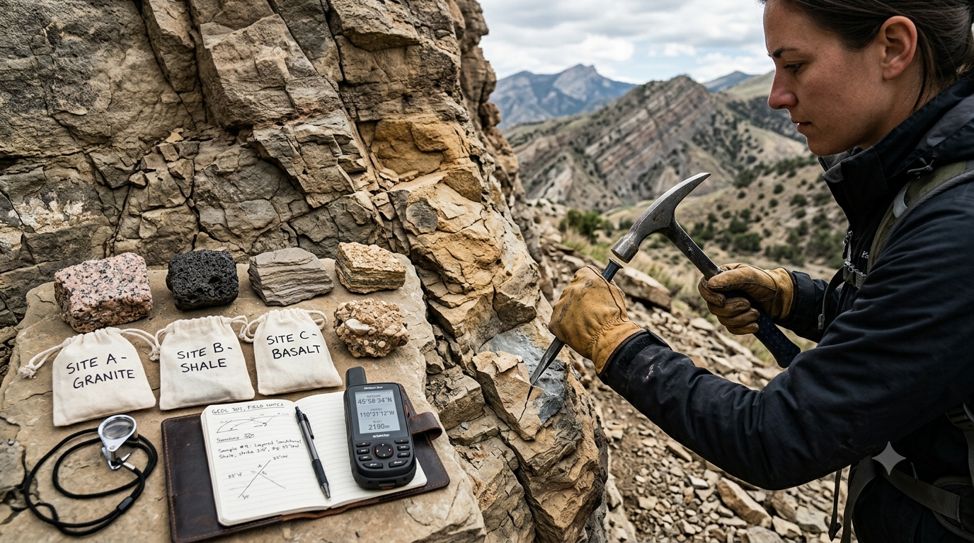
Geological sampling is an essential part of studying the Earth, understanding its structure, and identifying the materials that make up rocks and minerals. Geologists collect rock samples from different locations to investigate their composition, texture, age, origin, and physical properties. These samples help scientists understand geological processes, identify mineral resources, evaluate construction materials, and assess environmental conditions. Geological sampling is widely used in mineral exploration, engineering geology, environmental studies, petroleum geology, and academic research.
Collecting a rock sample may appear simple, but obtaining a useful and representative sample requires careful planning, suitable tools, and proper documentation. A poorly collected sample may not accurately represent the rock formation from which it was taken. Therefore, geologists follow established sampling methods to reduce errors and maintain the quality of collected material. Understanding the basic methods of geological sampling helps students, researchers, and field professionals conduct reliable investigations and interpret geological information more effectively.
What Is Geological Sampling?
Geological sampling is the systematic process of collecting representative portions of rocks, minerals, soil, sediments, or other geological materials for examination and analysis. The collected material is studied in the field, in a laboratory, or through specialized testing procedures.
The primary purpose of geological sampling is to obtain information about the geological characteristics of a particular location or formation. Samples may be collected to identify minerals, determine chemical composition, study rock textures, measure physical properties, or investigate the distribution of valuable resources.
For example, a geologist studying a granite outcrop may collect samples to identify its constituent minerals, such as quartz, feldspar, and mica. Similarly, an engineering geologist may collect rock samples from a proposed tunnel site to evaluate the strength and durability of the surrounding rock.
The sampling method depends on the objective of the investigation, the type of geological material, the accessibility of the site, and the analysis required.
Importance of Geological Sampling
Geological sampling provides essential information about the composition, structure, and behavior of Earth materials. Its importance extends across several scientific and practical fields.
Mineral Exploration
Geologists collect rock samples to identify minerals and investigate the possible presence of economically valuable elements, including copper, iron, gold, and other metals. Laboratory analysis helps determine whether a geological area requires further exploration.
Engineering and Construction
Rock samples are collected before constructing buildings, bridges, tunnels, dams, roads, and other infrastructure. Testing these samples helps engineers evaluate rock strength, weathering, fractures, and suitability for construction.
Geological Research
Researchers use rock samples to study the formation and transformation of rocks, geological history, tectonic activity, and the processes responsible for shaping the Earth’s surface.
Environmental Investigations
Geological samples can help identify natural or human-related contamination in rocks, sediments, and soils. Such investigations are useful in assessing mining impacts, industrial pollution, and the movement of potentially harmful substances.
Petroleum and Energy Studies
Sampling and related subsurface investigations help geologists understand sedimentary formations, reservoir rocks, and geological structures associated with oil, natural gas, geothermal energy, and other resources.
Educational Purposes
Rock samples are widely used in schools, colleges, museums, and laboratories. They allow students to observe minerals, textures, structures, and rock types directly rather than relying only on illustrations.
Types of Geological Samples
Different geological investigations require different types of samples. Understanding these categories helps geologists select the appropriate collection method.
1. Rock Samples
Rock samples are solid pieces collected from exposed rock formations, cliffs, quarries, road cuts, or underground excavations. They may represent igneous, sedimentary, or metamorphic rocks.
Examples include granite, basalt, sandstone, limestone, slate, and marble. Rock samples are commonly used for mineral identification, petrographic studies, strength testing, and chemical analysis.
2. Soil Samples
Soil samples are collected from the Earth’s surface or from specific depths below ground level. They are used to study soil composition, engineering properties, weathering, and environmental conditions.
Although soil sampling is related to geological sampling, it requires methods appropriate to loose material rather than solid rock.
3. Sediment Samples
Sediment samples consist of loose particles deposited by rivers, lakes, oceans, glaciers, wind, or gravity. These materials can reveal information about erosion, transportation, deposition, and the geological history of an area.
4. Drill Core Samples
Drill core samples are cylindrical sections of rock recovered using specialized drilling equipment. They provide information about geological formations below the surface, where direct observation is not possible.
Core samples are especially valuable in mineral exploration, geotechnical investigations, and subsurface geological mapping.
5. Channel Samples
Channel samples are collected systematically along a defined line or channel cut across a rock exposure. They are often used to evaluate the variation of mineral content across a mineralized zone or geological layer.
The dimensions, orientation, and spacing of the sampling channel depend on the purpose of the investigation and the characteristics of the rock formation.
Basic Tools Used for Geological Sampling
The choice of tools depends on the rock type, collection environment, and sampling objective. Common tools include the following.
Geological Hammer
A geological hammer is used to break small pieces of rock from suitable exposures. It is commonly used for collecting hand specimens and examining fresh rock surfaces.
Different hammer designs are available for different geological materials. The tool should be appropriate for the rock and used carefully to avoid unnecessary damage.
Chisel
A geological chisel helps remove rock fragments from surfaces where a hammer alone is insufficient. It is particularly useful when a sample must be separated from a larger rock mass.
Hand Lens
A hand lens, commonly with approximately 10× magnification, helps geologists examine mineral grains, crystal shapes, grain boundaries, and other small-scale features in the field.
Geological Field Notebook
A field notebook is used to record the sample location, rock type, geological observations, collection conditions, and other relevant details.
Accurate notes are essential because the scientific value of a sample depends partly on knowing where and how it was collected.
Sample Bags and Containers
Clean, durable bags or suitable containers are used to transport samples. The container should be appropriate for the material and the intended laboratory analysis.
GPS Device or Mapping Application
A GPS device or mapping application helps record the sample location. Accurate coordinates make it easier to revisit the sampling site and relate the sample to geological maps.
Labels and Permanent Markers
Every sample should receive a unique identification number. Labels and permanent markers help prevent confusion between samples collected from different locations.
Personal Protective Equipment
Safety equipment may include safety glasses, protective gloves, a helmet, sturdy footwear, and a high-visibility vest where appropriate. Additional protection may be necessary when working near cliffs, quarries, roads, or drilling equipment.
Basic Methods of Collecting Rock Samples
Several methods are used to collect rock samples in geological investigations. The appropriate method depends on the purpose of the study, the accessibility of the rock, and the type of information required.
1. Grab Sampling
Grab sampling involves collecting individual pieces of rock from a geological exposure, loose rock deposit, or other accessible location.
It is one of the simplest methods of geological sampling and is often used during preliminary field investigations. A geologist may select a fresh piece of rock from an outcrop to identify its minerals, texture, and general composition.
Procedure:
Identify a suitable rock exposure or location.
Examine the rock to determine whether it is representative of the material being investigated.
Select a suitable piece of rock, preferably avoiding visibly contaminated or heavily weathered surfaces when fresh material is required.
Collect the sample using appropriate tools and safety precautions.
Assign a unique sample identification number.
Record the location and relevant geological observations.
Grab sampling is useful for reconnaissance surveys and preliminary mineral identification. However, a single hand-selected sample may not represent the entire rock formation. It should not be used alone to estimate the average grade of a mineral deposit unless the sampling design and analytical evidence support that interpretation.
2. Chip Sampling
Chip sampling involves collecting small pieces of rock from a defined area or interval along a rock exposure. The chips are combined to create a sample for analysis.
This method can provide more representative information than collecting a single selected fragment when the collection is conducted systematically.
Procedure:
Select a suitable rock exposure.
Define the area or interval to be sampled.
Remove loose material and unsuitable surface debris where necessary.
Collect rock chips at regular intervals across the selected area.
Combine the chips according to the sampling plan.
Place the material in a labeled sample bag.
Record the sample boundaries, location, and collection method.
Chip sampling is commonly used in mineral exploration and geological surveys. The spacing and quantity of chips should be appropriate to the geological variability of the exposure and the objectives of the investigation.
Care must be taken to avoid selecting only visually attractive mineral-rich pieces, as this can introduce sampling bias.
3. Channel Sampling
Channel sampling involves collecting rock material along a continuous, defined channel cut across a rock face or mineralized zone. The channel is generally designed to cross the geological feature of interest rather than follow only its richest or most obvious portions.
This method is often used in mineral exploration to investigate the distribution of mineralization across exposed rock formations.
Procedure:
Identify the geological feature or mineralized zone to be investigated.
Determine the appropriate channel position and orientation.
Mark the channel boundaries and sampling interval.
Use suitable tools to remove rock material along the defined channel.
Collect the material consistently across the entire interval.
Package and label the sample.
Document the channel dimensions, orientation, location, and geological characteristics.
Channel sampling is particularly useful when geologists need to compare mineral content across different parts of an exposed formation. The results depend on correct channel placement, consistent collection, and suitable sample preparation.
Because cutting a channel into rock can be hazardous, this method should be carried out only where conditions are safe and the work is permitted.
4. Trench Sampling
Trench sampling involves collecting geological material from a trench excavated to expose rock or mineralized layers beneath soil, vegetation, or weathered surface material.
Trenches are often used during mineral exploration when the geological features of interest are concealed near the surface.
Procedure:
Select an investigation area based on geological mapping or preliminary survey results.
Plan the trench location and excavation method.
Ensure that excavation complies with relevant safety requirements and local regulations.
Expose the geological layers of interest.
Identify the boundaries of the rock units or mineralized zones.
Collect samples using a suitable method, such as channel sampling.
Record the location, depth, geological sequence, and sample intervals.
Trench sampling can reveal changes in rock type, weathering, and mineral distribution over short distances. However, trenches require more time, equipment, and planning than ordinary surface sampling.
Excavation stability, buried utilities, groundwater, and access restrictions must be considered before trenching begins.
5. Core Sampling
Core sampling involves recovering cylindrical rock specimens using specialized drilling equipment fitted with a core barrel and an appropriate drill bit.
Unlike surface sampling methods, core sampling provides information about geological formations below the ground surface.
Procedure:
Identify a suitable drilling location based on the investigation plan.
Select the drilling equipment and core size required.
Drill into the ground using an appropriate technique.
Recover the cylindrical rock core.
Place the core in a designated core tray in the correct sequence.
Mark the drilling depth and sample intervals.
Record core recovery, rock types, fractures, weathering, and other relevant observations.
Select and prepare samples for the required laboratory tests.
Core samples are valuable for studying rock structures, mineral distribution, geological boundaries, and subsurface conditions. In engineering geology, they may also be used for strength testing and evaluating rock quality.
Maintaining the correct depth sequence is essential. Mixing core sections or losing track of drilling depths can reduce the reliability of the investigation.
6. Boulder and Float Sampling
Boulder sampling involves collecting samples from large, loose rock fragments, while float sampling generally refers to collecting loose rock fragments that have been transported away from their original bedrock source.
These methods can be useful during preliminary mineral exploration, particularly in areas where bedrock is covered by soil, vegetation, or transported sediments.
Procedure:
Examine the distribution and characteristics of loose rock fragments.
Identify rock pieces that may be relevant to the investigation.
Record their location, size, appearance, and geological setting.
Collect suitable fragments for identification or laboratory analysis.
Label and document each sample.
Investigate the possible source of the fragments through geological mapping and additional sampling.
An important limitation is that loose fragments may have travelled a considerable distance from their original source. Their collection locations do not necessarily indicate where the rock formed or where mineralization occurs.
7. Selective Sampling
Selective sampling involves deliberately collecting material with particular geological characteristics, such as visible mineralization, distinctive mineral grains, or unusual rock textures.
It is useful when the purpose is to identify a mineral, examine a geological feature, or obtain a specimen for detailed study.
However, selective sampling is not necessarily representative of the surrounding formation. Samples chosen because they appear unusually rich in a mineral may give misleading results if used to estimate the average composition or economic potential of an entire deposit.
Geologists should clearly identify selective samples in field records and distinguish them from systematic or representative samples.
8. Representative Sampling
Representative sampling is designed to obtain a sample that accurately reflects the characteristics of a defined rock mass, layer, or geological interval.
It is especially important when the purpose is to determine average chemical composition, mineral concentration, or engineering properties.
Procedure:
Define the geological material or population that the sample must represent.
Examine the variability of the rock formation.
Select an appropriate sampling design, including sample locations and intervals.
Collect material systematically rather than choosing only visually distinctive pieces.
Use suitable sample quantities and collection procedures.
Prevent contamination and unnecessary material loss.
Document the method so that the results can be interpreted correctly.
Representative sampling often requires several individual collections, depending on the size and variability of the target formation. A carefully designed sampling program is more reliable than assuming that one convenient rock fragment represents an entire outcrop.
Step-by-Step Procedure for Collecting a Rock Sample
Although the specific technique varies, most geological sampling activities follow a common sequence.
Step 1: Define the Objective
Before collecting material, determine why the sample is required. The objective may be mineral identification, chemical analysis, petrographic examination, engineering testing, or geological mapping.
The purpose determines the sampling method, sample quantity, container, and handling requirements.
Step 2: Select the Sampling Location
Choose a location that provides relevant geological information. Suitable sites may include natural outcrops, road cuts, quarries, river exposures, or authorized excavation areas.
Consider whether the exposed rock represents the geological unit under investigation.
Step 3: Observe the Rock Formation
Examine the rock’s color, grain size, mineral content, layering, fractures, weathering, and relationship with nearby rock units.
Record these observations before collecting the sample. They provide context that may not be obvious from the sample alone.
Step 4: Collect the Sample
Use the appropriate sampling method and suitable tools. Collect material from the intended interval or location, avoiding unnecessary contamination and unplanned mixing of different rock types.
When fresh rock is required, remove the weathered outer surface carefully where appropriate.
Step 5: Label the Sample
Assign a unique identification number to every sample. The label should remain associated with the material throughout transport, storage, preparation, and laboratory analysis.
Step 6: Record Field Information
Record the sample number, coordinates, date, rock type, sampling method, geological setting, and any observations relevant to interpretation.
Photographs of the sampling site can provide additional documentation.
Step 7: Package and Transport the Sample
Place the sample in a suitable bag, box, or container. Protect fragile specimens from breakage and prevent contamination between samples.
If the sample is intended for chemical or specialized testing, follow the laboratory’s requirements for packaging, preservation, and handling.
Step 8: Prepare the Sample for Analysis
Depending on the investigation, laboratory preparation may involve drying, crushing, splitting, grinding, polishing, or cutting a specimen.
Sample preparation should follow the requirements of the intended test. For example, a polished thin section is prepared differently from a powdered sample intended for chemical analysis.
Proper Labeling and Documentation of Rock Samples
Correct labeling is essential because geological analysis is meaningful only when the sample can be linked to its original location and collection conditions.
A sample record commonly includes:
Sample identification number: A unique code used to track the sample.
Location: Coordinates, map reference, or a sufficiently detailed site description.
Date of collection: The date on which the sample was obtained.
Rock type: The preliminary field identification, if known.
Sampling method: Grab, chip, channel, core, or another method.
Geological observations: Mineral content, texture, weathering, fractures, and relationships with nearby formations.
Sample depth or interval: Required for subsurface samples and systematic sampling.
Collector’s details: The responsible person or field team, according to project procedures.
Photographs: Images of the sample location and surrounding geology, where appropriate.
For laboratory investigations, additional information may include sample mass, preparation instructions, requested analyses, and chain-of-custody records.
A field notebook, sample register, or digital database can be used to maintain these details. Sample identification should remain consistent across all records and containers.
Factors Affecting the Quality of Geological Samples
The quality of a geological sample depends on several factors that must be considered during collection and handling.
Weathering
Weathering can alter the minerals and chemical composition of rocks. If the objective is to investigate fresh bedrock, heavily weathered surfaces may be unsuitable.
However, weathered material may be exactly what is required when studying weathering processes or near-surface environmental conditions.
Contamination
Contact with soil, vegetation, metal tools, lubricants, or other materials can affect certain analyses. Appropriate tools, clean containers, and suitable handling procedures help reduce contamination.
For trace-element or geochemical studies, sampling protocols may require specialized equipment and strict contamination controls.
Sample Size
The required sample size depends on the rock’s grain size, mineral distribution, heterogeneity, and the intended test.
A sample that is too small may fail to represent the material adequately, particularly when valuable minerals occur as scattered grains.
Sampling Bias
Sampling bias occurs when the collection method systematically favors certain types of material. For example, collecting only bright or visibly mineral-rich fragments may overestimate the abundance of a mineral in the surrounding rock.
A clearly defined sampling plan helps reduce this problem.
Sample Damage
Excessive hammering, careless transport, or improper storage can damage specimens. This may be particularly important when studying delicate structures, fractures, mineral relationships, or physical properties.
Inadequate Documentation
Even a technically good sample can lose much of its scientific value if its origin, depth, orientation, or collection method is not recorded properly.
Safety Precautions During Geological Sampling
Field safety is an essential part of geological sampling. Rock collection may involve sharp fragments, falling material, unstable surfaces, heavy tools, remote locations, and changing weather conditions.
Important precautions include:
Wear safety glasses when breaking rock and use suitable protective equipment.
Use a geological hammer and chisel correctly, checking tools for damage before use.
Avoid collecting samples beneath unstable cliffs or loose rock faces.
Keep a safe distance from operating machinery and vehicle traffic.
Do not enter unstable trenches, excavations, or unsupported underground openings.
Obtain permission before collecting samples from private land, protected areas, or restricted sites.
Follow applicable rules for collecting geological specimens, particularly fossils, minerals, and materials from protected locations.
Carry appropriate communication equipment, drinking water, first-aid supplies, and navigation tools when working in remote areas.
Follow laboratory and field protocols when samples may contain hazardous minerals or other harmful substances.
Safety requirements vary with the location and type of investigation. Where specialized drilling, excavation, blasting, or work at height is involved, trained personnel and appropriate risk assessments are necessary.
Applications of Geological Sampling
Geological sampling supports many practical activities and scientific investigations.
In mineral exploration, it helps identify mineralized zones and assess the distribution of economically important elements. In engineering geology, samples are used to determine rock strength, durability, density, and other properties relevant to construction.
In academic research, samples provide evidence for interpreting the origin and history of igneous, sedimentary, and metamorphic rocks. Environmental geologists use samples to investigate contamination, weathering, and sediment movement.
Geological sampling also supports quarry operations, groundwater investigations, geothermal studies, and the assessment of raw materials used in construction and manufacturing.
In all these applications, sampling results must be interpreted in relation to the geological setting, collection method, and laboratory procedures. A sample provides information about the material collected, but conclusions about a larger area require a suitable sampling design and supporting evidence.
Conclusion
Geological sampling is a fundamental method for collecting information about the Earth’s rocks, minerals, and geological formations. Basic methods such as grab sampling, chip sampling, channel sampling, trench sampling, core sampling, and representative sampling serve different purposes and provide different types of geological information.
The reliability of a sampling investigation depends on selecting an appropriate method, collecting material carefully, preventing contamination, maintaining accurate labels, and documenting the geological setting. Safety and permission to collect samples are equally important throughout fieldwork.
By following systematic procedures, geologists can obtain useful samples for laboratory analysis, mineral exploration, engineering projects, environmental investigations, and scientific research. A well-collected and properly documented rock sample becomes a valuable source of evidence for understanding geological processes and making informed decisions about the Earth’s resources and structure.
FAQs
1. What Is Geological Sampling?
Geological sampling is the process of collecting representative portions of rocks, minerals, soil, sediments, or other Earth materials for scientific examination and laboratory analysis. Geologists use samples to understand mineral composition, rock texture, chemical properties, geological history, and physical strength. The collected material may be studied to identify valuable minerals, evaluate construction materials, investigate environmental conditions, or understand geological processes. The sampling method depends on the purpose of the investigation and the type of material being studied. Proper collection, labeling, transportation, and documentation are essential for obtaining reliable results and drawing meaningful conclusions from geological investigations.
2. Why Is Geological Sampling Important?
Geological sampling is important because it provides direct evidence about the composition and characteristics of Earth’s materials. It helps geologists identify minerals, investigate potential mineral deposits, and understand the formation of different rock types. Engineers use rock samples to evaluate the suitability of geological formations for buildings, bridges, tunnels, and dams. Environmental scientists analyze samples to investigate contamination and natural geochemical processes. Researchers also use geological samples to study Earth’s history and the processes responsible for shaping its surface. Without reliable sampling, laboratory results may not accurately represent the investigated area, potentially leading to incorrect scientific interpretations or engineering decisions.
3. What Are the Main Methods of Collecting Rock Samples?
The main methods of collecting rock samples include grab sampling, chip sampling, channel sampling, trench sampling, core sampling, boulder sampling, and representative sampling. Grab sampling involves collecting individual rock pieces, while chip sampling collects small fragments across a defined area or interval. Channel sampling involves collecting material along a continuous channel cut across a rock exposure. Trench sampling provides access to geological layers beneath surface materials, and core sampling recovers cylindrical rock specimens through drilling. Representative sampling aims to reflect the characteristics of a defined geological material. Geologists select the appropriate method according to the investigation’s objectives, geological conditions, and required analysis.
4. What Tools Are Used for Geological Sampling?
Common tools used for geological sampling include geological hammers, chisels, sample bags, field notebooks, hand lenses, GPS devices, permanent markers, and protective equipment. Geological hammers and chisels help collect solid rock specimens, while hand lenses allow geologists to examine mineral grains and textures. GPS devices help record sampling locations, and field notebooks preserve geological observations. Clean containers and durable labels help protect and identify samples during transportation. More advanced investigations may require drilling equipment, core barrels, cutting tools, or specialized sampling instruments. The choice of tools depends on the rock type, collection method, safety requirements, and intended laboratory analysis.
5. What Is the Difference Between Grab Sampling and Chip Sampling?
Grab sampling involves collecting one or more selected rock fragments from an exposure or loose rock deposit. It is commonly used for preliminary geological identification and reconnaissance surveys. Chip sampling, in contrast, involves collecting small rock fragments systematically across a defined area or interval. When properly designed, chip sampling can provide a better representation of variations within the sampled exposure than a single selected fragment. However, neither method automatically guarantees representative results. Grab samples may overrepresent visually distinctive material, while poorly planned chip sampling can also introduce bias. The appropriate method depends on the geological objective and the characteristics of the rock formation.
6. What Is Channel Sampling in Geology?
Channel sampling is a geological method in which rock material is collected along a continuous, defined channel cut across an exposed rock surface. It is commonly used in mineral exploration to investigate the distribution of mineralization across a geological zone. The channel should be positioned according to the investigation’s objectives and the orientation of the geological feature being studied. Geologists collect material consistently along the specified interval and document its dimensions, location, and geological characteristics. Channel sampling can help compare mineral concentrations across exposed formations. However, the reliability of results depends on correct channel placement, consistent collection, suitable sample preparation, and appropriate laboratory analysis.
7. What Is Core Sampling and Why Is It Used?
Core sampling is a method of collecting cylindrical rock specimens using specialized drilling equipment. It allows geologists to investigate geological formations beneath the Earth’s surface, where direct observation is difficult or impossible. Recovered cores provide information about rock types, mineral distribution, fractures, weathering, and geological boundaries. In engineering geology, core samples may be tested to evaluate rock strength and other physical properties. In mineral exploration, they help investigate potentially valuable deposits at different depths. Each core section must be placed in the correct sequence and labeled with its depth information. Accurate documentation is essential for interpreting the geological conditions encountered during drilling.
8. How Should Rock Samples Be Labeled and Stored?
Rock samples should be assigned unique identification numbers and placed in suitable, clearly labeled containers. Important records include the sample location, collection date, rock type, sampling method, depth or interval where applicable, and relevant geological observations. GPS coordinates and photographs can provide additional information about the collection site. Samples should be protected from unnecessary breakage, contamination, and material loss during transportation and storage. If chemical or specialized testing is planned, the packaging and handling procedures should follow the laboratory’s requirements. Maintaining consistent identification across sample bags, field notebooks, and laboratory records helps prevent confusion and ensures that analytical results can be linked to their original locations.
9. What Factors Affect the Quality of Geological Samples?
Several factors influence geological sample quality, including weathering, contamination, sample size, sampling bias, physical damage, and inadequate documentation. Weathered surfaces may not represent fresh bedrock, although they can be appropriate for studies of weathering processes. Contamination from soil, dirty tools, or unsuitable containers can affect chemical analyses. Samples that are too small may not represent rocks containing unevenly distributed minerals. Sampling bias occurs when particular materials are preferentially selected, potentially producing misleading results. Physical damage can destroy important textures or structures, while missing location information reduces scientific usefulness. Careful planning, systematic collection, suitable packaging, and accurate documentation help minimize these problems.
10. What Safety Precautions Should Be Followed During Geological Sampling?
Geological sampling requires appropriate safety precautions because fieldwork may involve sharp rock fragments, falling debris, unstable cliffs, heavy tools, and hazardous environments. Geologists should wear safety glasses when breaking rocks and use suitable gloves, protective footwear, helmets, and other equipment as required. Unstable slopes and loose rock faces should be avoided, and sampling should never be conducted beneath potentially falling material. Tools must be handled correctly, and road traffic, machinery, and excavation hazards must be considered. Permission should be obtained before collecting specimens from restricted or private locations. Drilling and trenching require additional controls, appropriate training, and compliance with relevant safety regulations.