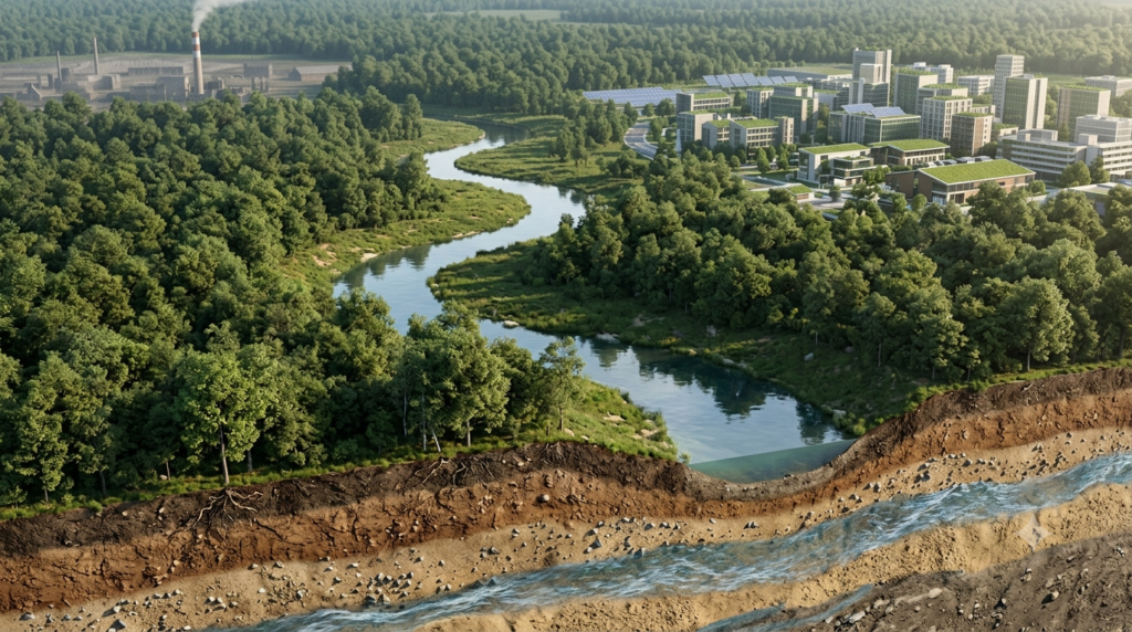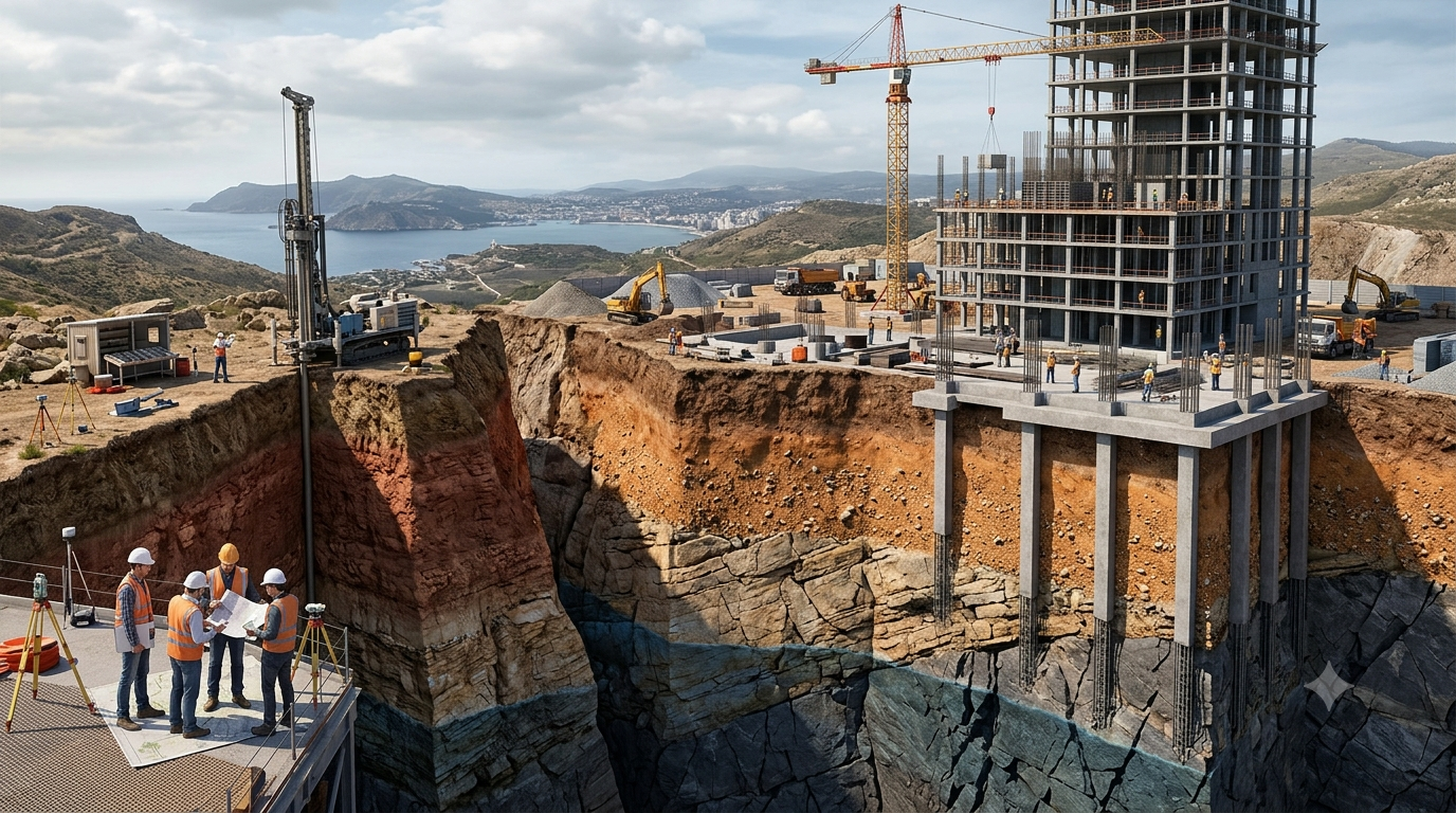
Engineering geology is an important branch of geology that applies geological knowledge to engineering design, construction, and infrastructure development. It helps engineers understand the materials and natural conditions beneath and around a construction site before building structures such as houses, bridges, roads, tunnels, dams, and industrial facilities. The strength of a structure depends not only on its design and construction quality but also on the stability of the ground supporting it.
Rocks, soil, groundwater, faults, earthquakes, landslides, and other geological features can significantly influence construction projects. If these factors are not properly investigated, they may lead to foundation failure, structural damage, construction delays, and increased costs. Engineering geology helps identify these risks at an early stage and supports the selection of suitable construction methods. By combining geological observations with engineering principles, it contributes to safer, more durable, and economically efficient infrastructure.
What Is Engineering Geology?
Engineering geology is the study of geological conditions that affect the planning, design, construction, operation, and maintenance of engineering projects. It focuses on understanding the physical properties of rocks and soils, the structure of the Earth’s crust, groundwater conditions, and geological processes that may influence the performance of a structure.
Engineering geologists examine the ground to determine whether it can safely support a proposed building or infrastructure project. They investigate the distribution of soil and rock layers, the presence of fractures or faults, the movement of groundwater, and the possibility of natural hazards.
For example, a building constructed on strong, stable bedrock may require a different foundation system from a building constructed on soft clay or loose sand. Similarly, a road crossing a mountainous region may need detailed investigations to identify unstable slopes and potential landslide zones.
Engineering geology provides the information needed to make these decisions. It works closely with civil engineers, geotechnical engineers, architects, environmental specialists, and construction professionals.
Importance of Engineering Geology in Construction Projects
Engineering geology is essential because every construction site has its own geological characteristics. Even two nearby locations can have different soil strengths, groundwater levels, and rock structures. Understanding these differences helps engineers choose appropriate designs and avoid unexpected problems during construction.
1. Identifying Suitable Construction Sites
Selecting an appropriate construction site is one of the first steps in any major engineering project. Engineering geology helps determine whether a location is suitable for the proposed structure.
Geologists examine the ground surface, rock formations, soil conditions, drainage patterns, slope stability, and nearby geological hazards. They also consider whether the area contains weak ground, unstable deposits, active faults, or evidence of previous landslides.
For example, a site located on stable ground with adequate bearing capacity may be suitable for a large building. However, a site containing thick layers of compressible clay may require special foundation treatment or a different structural design.
Early geological investigations help project planners compare possible locations and select the most appropriate site.
2. Foundation Design and Stability
Foundations transfer the weight of a structure to the underlying soil or rock. Their safety depends on the strength, stiffness, and settlement characteristics of the supporting ground.
Engineering geology helps identify the depth and thickness of soil and rock layers, the presence of weak zones, and variations in ground conditions. This information supports the selection of suitable foundation types.
Common foundation systems include shallow foundations, raft foundations, and deep foundations such as piles and drilled shafts. The choice depends on the structure’s loads and the properties of the ground.
For instance, shallow foundations may be suitable where strong soil or rock exists near the surface. If weak soil extends to considerable depths, engineers may use piles to transfer loads to stronger layers below.
A proper understanding of geological conditions reduces the risk of excessive settlement, foundation cracking, tilting, and structural instability.
3. Investigation of Soil and Rock Properties
Soil and rock are the primary materials that support most construction projects. Their engineering properties vary considerably depending on their origin, composition, weathering, and geological history.
Engineering geologists study characteristics such as rock strength, soil consistency, fractures, porosity, permeability, and weathering. These properties influence how the ground behaves under loads and during excavation.
Strong, unweathered rock may provide reliable support, whereas highly fractured or weathered rock may have lower strength and greater water permeability. Similarly, loose sand may behave differently from dense sand, while soft clay can undergo significant settlement under sustained loads.
Geological mapping, boreholes, laboratory testing, and field investigations help identify these conditions. Engineers use the findings to develop suitable foundation designs and construction procedures.
4. Groundwater Investigation and Control
Groundwater is an important factor in construction because it affects excavation stability, foundation performance, and the durability of underground structures.
A high groundwater table can make excavation difficult by allowing water to enter foundation pits and trenches. In certain soil conditions, groundwater movement may also cause erosion, piping, or instability. Water pressure within rock fractures can influence the stability of slopes, tunnels, and underground excavations.
Engineering geologists investigate groundwater levels, flow directions, rock permeability, and seasonal variations in water availability. These findings help engineers plan drainage systems, waterproofing, dewatering, and other protective measures.
For example, basement construction in an area with a high groundwater table may require temporary pumping during excavation and permanent waterproofing after construction. In dam projects, groundwater investigations help assess seepage through the foundation and surrounding rock.
Proper groundwater management improves construction safety and helps protect structures from water-related damage.
Major Applications of Engineering Geology
1. Engineering Geology in Building Construction
Buildings transfer substantial loads to the ground, making geological investigations essential for their safety and stability.
Before construction begins, engineers need information about soil thickness, bedrock depth, groundwater conditions, and the possibility of settlement. These factors become especially important for high-rise buildings, hospitals, commercial complexes, and structures with heavy foundations.
Engineering geology also helps identify ground conditions that may complicate excavation. For example, cavities in limestone formations, abandoned underground workings, or loose artificial fill can create unexpected foundation problems.
Where weak ground is identified, engineers may consider ground improvement, foundation redesign, or alternative construction locations. This reduces the likelihood of expensive repairs and structural damage in the future.
2. Engineering Geology in Road Construction
Roads often pass through different geological environments, including plains, river valleys, hills, and mountainous regions. Each environment presents specific construction challenges.
Engineering geologists examine the strength of subgrade materials, slope conditions, rock formations, drainage patterns, and the likelihood of landslides. They also identify areas where erosion or settlement could damage the road surface.
In mountainous terrain, road construction may require cutting through rock slopes. If the rock contains fractures, weak layers, or unfavourably oriented discontinuities, the cut slope may become unstable.
Geological investigations help determine suitable slope angles, drainage requirements, and protective measures such as retaining structures, rock bolts, and erosion-control systems.
Understanding local geology also helps engineers select suitable construction materials and reduce the risk of road failure.
3. Engineering Geology in Bridge Construction
Bridges must safely transfer loads from their decks and supporting structures to the ground. The geological conditions beneath bridge piers and abutments are therefore extremely important.
Engineering geologists investigate the depth of bedrock, soil strength, rock discontinuities, groundwater, and the characteristics of river sediments. They also examine the potential effects of erosion and scour around foundations.
Scour occurs when flowing water removes soil or sediment around a bridge foundation. If the foundation becomes exposed or loses sufficient support, the bridge may become unstable.
Geological and subsurface investigations help engineers select appropriate foundation depths and construction methods. They also support assessments of riverbank stability and the suitability of locations for bridge abutments.
4. Engineering Geology in Dam Construction
Dams require particularly careful geological investigations because they hold large volumes of water and experience significant forces.
The foundation and surrounding rock must provide adequate strength and stability. Engineers must also evaluate whether water can seep through fractures, faults, permeable rock layers, or weak zones beneath and around the dam.
Engineering geologists examine rock types, geological structures, groundwater conditions, weathering, and possible seepage pathways. They also assess the stability of the reservoir slopes.
If investigations identify permeable or fractured rock, engineers may use measures such as grouting, drainage galleries, or cutoff systems to control seepage.
Geological investigations are also important when assessing whether an area is susceptible to earthquakes or reservoir-induced slope instability. These studies help improve dam safety and reduce the risk of serious failure.
5. Engineering Geology in Tunnel Construction
Tunnels are built through soil, rock, or a combination of geological materials. Conditions underground can change significantly over short distances, making geological investigation especially important.
Engineering geologists identify rock types, fractures, faults, groundwater inflows, weak zones, and potentially unstable ground. They help predict how the surrounding material may behave during excavation.
Strong, relatively unfractured rock may remain stable during excavation, while heavily fractured rock may require immediate support. Water-bearing fractures can cause sudden inflows, delays, and additional safety risks.
Geological information helps engineers select appropriate tunnelling methods, excavation sequences, support systems, and waterproofing measures.
It is particularly valuable for road tunnels, railway tunnels, hydropower tunnels, and underground transportation systems.
6. Engineering Geology in Mining and Underground Structures
Mining projects and underground structures involve excavations that may alter the natural stress conditions within rocks. Geological investigations are necessary to understand the stability of underground openings and surrounding ground.
Engineering geologists identify rock formations, faults, joints, weak layers, and groundwater pathways. These features influence the possibility of rockfalls, roof collapse, subsidence, and water inflow.
For underground parking facilities, metro stations, utility corridors, and mining excavations, geological information helps determine suitable excavation and support methods.
The findings can also assist in identifying abandoned mine workings or underground cavities that could affect nearby construction.
Geological Hazards and Their Impact on Construction
One of the most important responsibilities of engineering geology is identifying natural geological hazards that may threaten infrastructure.
1. Earthquakes
Earthquakes generate ground shaking that can damage buildings, bridges, dams, and other structures. Geological investigations help identify active faults, local soil conditions, and areas that may experience amplified ground motion.
Soft soil deposits can amplify earthquake shaking compared with competent bedrock. Certain loose, saturated sandy soils may also be susceptible to liquefaction, in which the soil temporarily loses much of its strength during strong shaking.
Engineering geologists provide information that supports seismic hazard assessments and appropriate foundation design. Structural engineers then use this information to design buildings and infrastructure according to relevant seismic standards.
2. Landslides
Landslides occur when soil, rock, or debris moves downslope under the influence of gravity. They can damage roads, buildings, pipelines, and other infrastructure.
Common contributing factors include heavy rainfall, weathered rock, weak geological layers, steep slopes, erosion, and excavation at the base of a hillside.
Engineering geologists examine slope geometry, rock discontinuities, groundwater conditions, and evidence of previous slope movement. Their findings help engineers identify unstable areas and design suitable protective measures.
Possible measures include surface drainage, retaining walls, slope reinforcement, rock bolts, and changes to slope geometry. The appropriate solution depends on the cause and nature of the instability.
3. Soil Erosion and Subsidence
Soil erosion removes surface material through the action of water or wind. It can weaken embankments, expose foundations, damage road surfaces, and affect drainage systems.
Subsidence refers to the gradual or sudden downward movement of the ground. It may occur because of groundwater extraction, underground mining, the collapse of cavities, or the compression of soft soil.
Engineering geology helps identify locations where these processes may occur and supports the development of preventive measures.
For example, areas with soluble limestone may contain underground cavities formed by dissolution. If such cavities are not identified before construction, the ground may settle or collapse under additional loads.
Methods Used in Engineering Geological Investigations
Engineering geologists use several methods to understand the ground conditions at a construction site.
1. Geological Mapping
Geological mapping involves examining and recording the distribution of rocks, soil deposits, faults, joints, folds, and other geological features.
It helps establish the geological framework of a site and identify features that may affect construction. Mapping is particularly useful for roads, dams, tunnels, and projects in mountainous terrain.
2. Borehole Drilling and Sampling
Boreholes allow investigators to examine underground materials directly. Soil and rock samples can be collected at different depths and tested to determine their properties.
Borehole logs record information such as material types, layer thicknesses, groundwater observations, and the condition of recovered rock.
These records help engineers understand variations beneath the surface and select suitable foundation depths.
3. Geophysical Surveys
Geophysical techniques investigate the subsurface by measuring physical properties such as electrical resistivity, seismic-wave velocity, or variations in gravity.
Methods such as seismic refraction and electrical resistivity surveys can help identify changes in underground materials, estimate bedrock depth, and locate possible cavities or groundwater-related features.
Geophysical surveys are useful because they can cover larger areas without requiring extensive drilling. However, their results generally need to be interpreted alongside geological observations and, where appropriate, borehole data.
4. Laboratory and Field Testing
Soil and rock samples are tested to evaluate their engineering properties. Common investigations include soil classification, shear strength testing, compressibility testing, rock strength testing, and permeability measurements.
Field tests may include standard penetration tests, cone penetration tests, and rock mass investigations, depending on the project and ground conditions.
The results help engineers estimate bearing capacity, settlement, slope stability, and the suitability of materials for construction.
5. Groundwater Monitoring
Groundwater levels can be monitored using suitable instruments installed in boreholes or observation wells. Repeated measurements help identify seasonal changes and groundwater responses to rainfall or construction activities.
Monitoring is particularly important for deep excavations, tunnels, dams, and structures built below the water table.
Benefits of Engineering Geology in Construction
Engineering geology provides several important benefits throughout a construction project’s life cycle.
Improved safety: Identifying weak ground, unstable slopes, active faults, and groundwater hazards helps reduce the risk of structural failure and construction accidents.
Cost control: Early investigations can reveal difficult ground conditions before major construction begins. This allows project teams to plan suitable solutions and reduce expensive changes during construction.
Better foundation design: Reliable geological information supports the selection of appropriate foundation systems and reduces the risk of excessive settlement or instability.
Efficient construction: Understanding the expected ground conditions helps contractors plan excavation, drainage, support systems, and equipment requirements more effectively.
Long-term durability: Managing seepage, erosion, slope instability, and ground movement helps extend the service life of infrastructure.
Environmental protection: Geological investigations can identify sensitive groundwater systems, unstable land, and areas where construction may affect natural drainage or geological resources.
Together, these benefits improve the technical reliability and economic performance of construction projects.
Role of Engineering Geologists During Different Project Stages
Engineering geology is not limited to the initial site investigation. Its role continues throughout the development and operation of infrastructure.
During the planning stage, engineering geologists help assess site suitability, geological hazards, and possible construction constraints.
During the design stage, they provide information about soil and rock properties, groundwater, faults, and slope conditions. Engineers use this information to develop suitable foundations and other structural systems.
During construction, engineering geologists may examine exposed rock surfaces, evaluate unexpected ground conditions, monitor slope behaviour, and advise on excavation support. Their observations are especially valuable when actual geological conditions differ from those predicted during the investigation.
After construction, geological monitoring may be required for dams, tunnels, major slopes, underground structures, and other infrastructure exposed to continuing geological processes.
Monitoring can include groundwater measurements, slope movement surveys, settlement observations, and inspections of geological features. These activities help identify potential problems before they become serious.
Challenges in Engineering Geology
Despite its importance, engineering geological investigation has certain limitations.
The ground is naturally variable, and conditions between boreholes may differ from those observed at investigated locations. Some geological features, such as small faults, buried cavities, or isolated weak zones, may remain undetected during preliminary surveys.
Access limitations, project budgets, weather, and difficult terrain can also restrict the extent of field investigations. In addition, groundwater conditions may change seasonally or in response to construction activities.
These challenges make it important to combine multiple investigation methods, interpret results carefully, and allow for uncertainty during design.
Construction teams should also establish procedures for responding to unexpected ground conditions. Additional investigations, revised designs, and appropriate monitoring may be necessary when new geological information becomes available.
Conclusion
Engineering geology plays a vital role in the safe and successful development of construction projects. By examining soil, rock, groundwater, geological structures, and natural hazards, it provides essential information for site selection, foundation design, excavation planning, and infrastructure protection.
Its applications extend across buildings, roads, bridges, dams, tunnels, and underground facilities. Through geological mapping, borehole investigations, geophysical surveys, laboratory testing, and groundwater monitoring, engineering geologists help identify potential problems before they threaten a project.
Although geological conditions can be complex and sometimes unpredictable, careful investigation and continuous assessment significantly reduce uncertainty. Cooperation between engineering geologists, civil engineers, geotechnical specialists, and construction teams leads to better-informed decisions, improved safety, reduced costs, and more durable infrastructure. Engineering geology is therefore a fundamental part of responsible construction and long-term infrastructure development.
FAQs
1. What is engineering geology?
Engineering geology is a branch of geology that applies geological knowledge to engineering and construction activities. It involves studying rocks, soil, groundwater, geological structures, and natural hazards that may affect the safety and stability of infrastructure. Engineering geologists investigate construction sites to determine whether the ground is suitable for buildings, bridges, roads, dams, and tunnels. They provide important information about foundation conditions, slope stability, groundwater movement, and potential geological risks. This knowledge helps engineers select appropriate construction methods, design safer foundations, reduce project costs, and improve the long-term performance of structures.
2. Why is engineering geology important in construction projects?
Engineering geology is important because the stability of a structure depends partly on the geological conditions of its construction site. Weak soil, fractured rocks, groundwater, and unstable slopes can create serious problems if they are not identified before construction. Engineering geological investigations help determine ground strength, foundation suitability, and potential hazards. This information allows engineers to develop appropriate designs and choose suitable construction methods. It also reduces the likelihood of foundation failure, excessive settlement, landslides, and water-related damage. By identifying risks early, engineering geology supports safer construction, better planning, reduced expenses, and more durable infrastructure.
3. How does engineering geology help in foundation design?
Engineering geology supports foundation design by providing information about the soil and rock beneath a proposed structure. Investigations identify the thickness of different ground layers, the depth of bedrock, groundwater conditions, and the presence of weak or fractured materials. These properties influence the foundation’s bearing capacity and settlement behaviour. Based on the findings, engineers can determine whether a shallow foundation, raft foundation, or deep foundation is more appropriate. For example, piles may be required when weak soil extends to considerable depths. Understanding geological conditions helps prevent excessive settlement, foundation cracking, tilting, and other problems that could threaten structural stability.
4. What are the main methods used in engineering geological investigations?
Engineering geological investigations use several methods to understand subsurface conditions. Geological mapping identifies rock types, faults, joints, folds, and other geological features. Borehole drilling provides information about underground soil and rock layers through sampling and logging. Geophysical surveys, including seismic refraction and electrical resistivity, help investigate subsurface variations without extensive excavation. Laboratory tests determine soil and rock properties such as strength, permeability, and compressibility. Field tests provide additional information about ground behaviour. Groundwater monitoring helps establish water levels and seasonal changes. Combining these methods gives engineers a more reliable understanding of construction conditions and potential geological risks.
5. What role does engineering geology play in dam construction?
Engineering geology is essential in dam construction because dams must remain stable while resisting water pressure and other forces. Geological investigations assess the strength of foundation rocks, the presence of faults and fractures, groundwater conditions, and the possibility of seepage beneath or around the structure. Engineers also investigate the stability of slopes surrounding the proposed reservoir. If the foundation contains permeable or fractured rock, measures such as grouting and drainage systems may be necessary to control water movement. Geological assessments also contribute to earthquake hazard evaluation. Understanding these conditions helps engineers select suitable dam locations, improve foundation treatment, and reduce the risk of structural failure.
6. How does engineering geology help prevent landslides?
Engineering geology helps prevent landslide-related damage by identifying unstable slopes and understanding the factors that may cause ground movement. Engineering geologists examine rock fractures, soil composition, slope angles, groundwater conditions, erosion, and evidence of previous landslides. They assess whether rainfall, excavation, or changes in drainage could increase instability. Based on these findings, engineers can develop appropriate protective measures, such as retaining walls, slope reinforcement, rock bolts, drainage channels, and modifications to slope geometry. Monitoring systems may also be installed to detect ground movement. Although not every landslide can be prevented, geological investigations help reduce risks to construction workers, buildings, roads, and nearby communities.
7. What is the difference between engineering geology and geotechnical engineering?
Engineering geology and geotechnical engineering are closely related but have different primary focuses. Engineering geology examines the geological origin, structure, distribution, and behaviour of soil and rock in relation to engineering projects. It identifies geological features and natural processes that may influence construction. Geotechnical engineering applies engineering principles to evaluate ground behaviour and design foundations, retaining structures, excavations, embankments, and slopes. For example, an engineering geologist may identify fractured bedrock and groundwater pathways at a site, while a geotechnical engineer uses investigation results and calculations to design a suitable foundation. Both disciplines work together to improve construction safety and performance.
8. How does groundwater affect construction projects?
Groundwater can significantly influence excavation, foundation stability, and the durability of underground structures. A high groundwater table may cause water to enter foundation pits, basements, and tunnels, making construction more difficult. In certain soil conditions, uncontrolled groundwater movement can contribute to erosion, piping, or excavation instability. Water pressure within rock fractures can also affect slope and tunnel stability. Engineering geological investigations help determine groundwater levels, flow patterns, permeability, and possible seasonal variations. Engineers may use dewatering systems, drainage arrangements, waterproofing, and foundation treatments to manage these conditions. Proper groundwater assessment reduces construction delays and helps protect completed structures from water-related damage.
9. How does engineering geology contribute to road and tunnel construction?
Engineering geology helps road and tunnel construction teams understand the ground conditions along a proposed route. For roads, geological investigations identify weak subgrade materials, unstable slopes, erosion risks, and areas susceptible to landslides. For tunnels, investigations examine rock strength, faults, fractures, groundwater inflows, and potentially unstable zones. This information helps engineers choose suitable excavation methods, tunnel support systems, road-cut slope designs, and drainage arrangements. Geological mapping, boreholes, and geophysical surveys can reveal important underground features before excavation begins. Identifying difficult ground conditions early helps reduce accidents, construction delays, unexpected expenses, and long-term maintenance problems.
10. What are the long-term benefits of engineering geology in infrastructure development?
Engineering geology provides long-term benefits by helping infrastructure projects withstand geological conditions throughout their service lives. Proper investigations support suitable foundations, effective drainage, stable slopes, and appropriate protection against groundwater and natural hazards. These measures reduce the likelihood of structural damage, settlement, erosion, and costly repairs. Geological information also helps engineers plan maintenance and monitoring for dams, tunnels, bridges, roads, and other major structures. In addition, identifying sensitive geological environments can help reduce adverse effects on groundwater and surrounding land. By improving safety, durability, and resource management, engineering geology contributes to more reliable, economical, and sustainable infrastructure development.